Choose the kind of Fiordland day you want.
The best attractions are not all the same kind of beautiful. Some are big and dramatic, some are quiet, and some work because you slow down.
Fiords first
Milford and Doubtful are the headline days, but they feel very different. Pick drama, silence, or both.
Easy magicCaves and lake
The glowworm caves and lakefront experiences are strong choices when the weather is mixed.
TracksGreat Walk country
Use Te Anau as the base for Kepler, Milford, Routeburn, and shorter forest walks.
WeatherRain is part of it
Fiordland often looks most alive in mist and rain, especially around waterfalls and forest.
Milford Sound - The 8th Wonder of the World
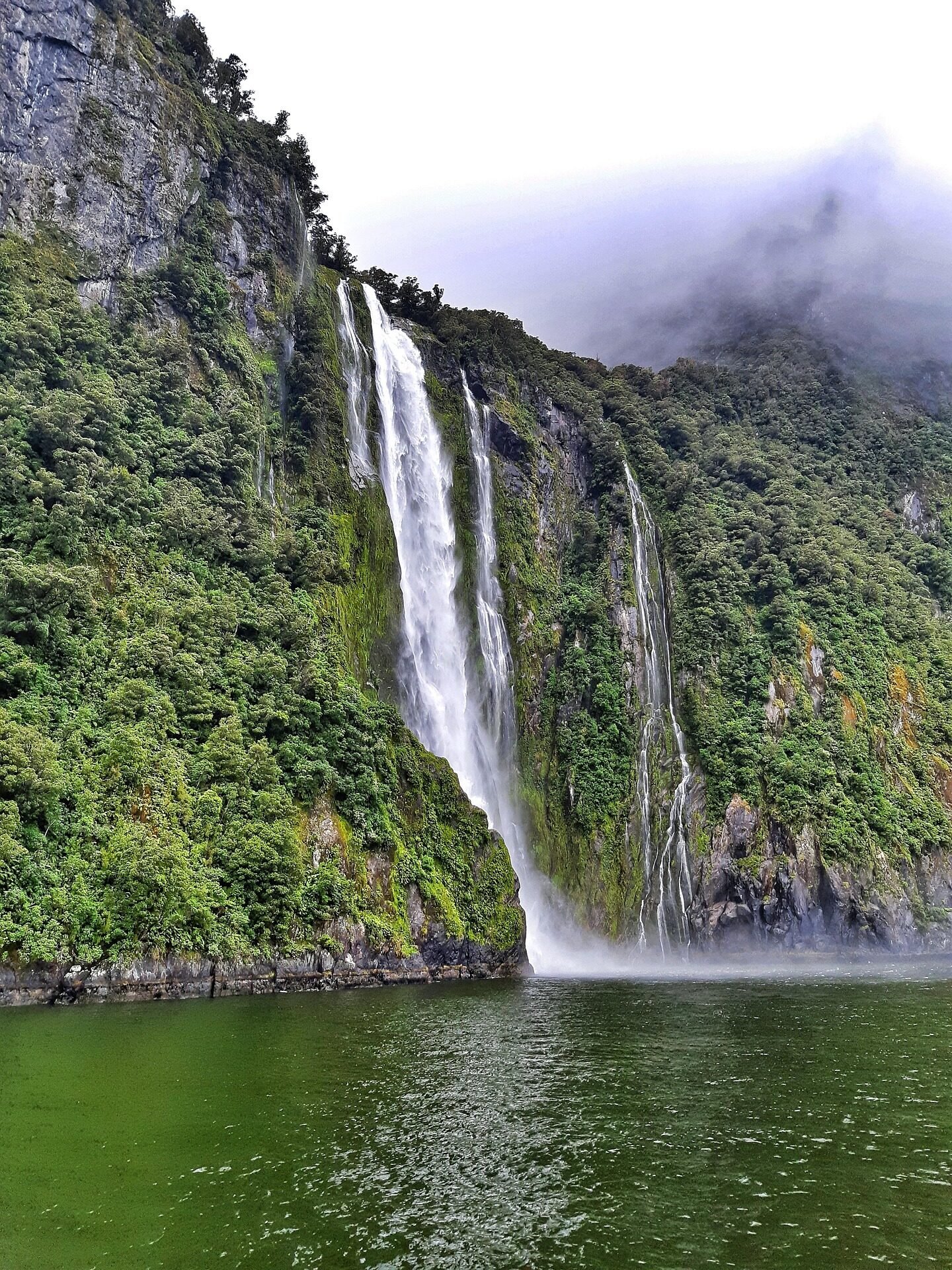
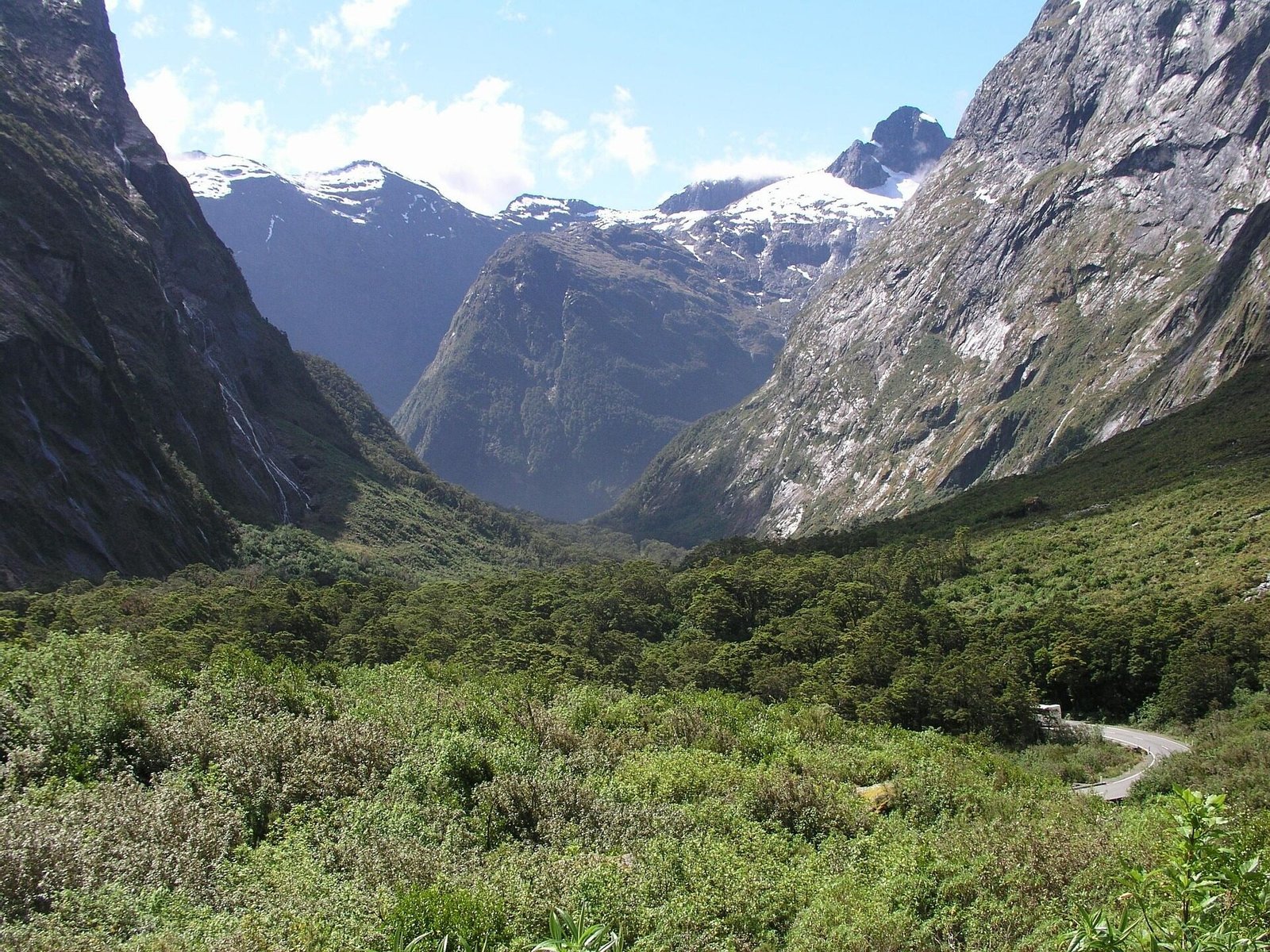
Milford Sound (Piopiotahi in Māori) is New Zealand's most famous tourist destination and one of the most spectacular natural attractions on Earth. This stunning fiord was carved by glaciers during the ice ages, creating dramatic landscapes where mountains rise vertically from the sea to heights of over 1,200 meters.
Insider Tips for Milford Sound
- Best Time: Visit on rainy days - waterfalls are 10x more spectacular (200+ temporary falls)
- Save Money: Book direct with cruise operators, not through hotels (save $20-40)
- Avoid Crowds: First cruise (9am) or last cruise (3pm) have fewer people
- Photography: Overcast days produce better photos than sunny days
- Hidden Gem: Walk to Bowen Falls lookout (5 min) before your cruise - free and stunning
Key Features
Mitre Peak: The iconic 1,692-meter peak rises directly from the waters of Milford Sound, making it one of the world's tallest sea cliffs. Named by Captain John Lort Stokes in 1851 for its resemblance to a bishop's mitre, this peak is the most photographed mountain in New Zealand.
Waterfalls: Milford Sound features numerous permanent and temporary waterfalls. Stirling Falls (155m) and Bowen Falls (162m) are the two permanent falls that cascade year-round. After heavy rain (which occurs about 200 days per year), hundreds of temporary waterfalls appear on the cliff faces, creating an unforgettable spectacle.
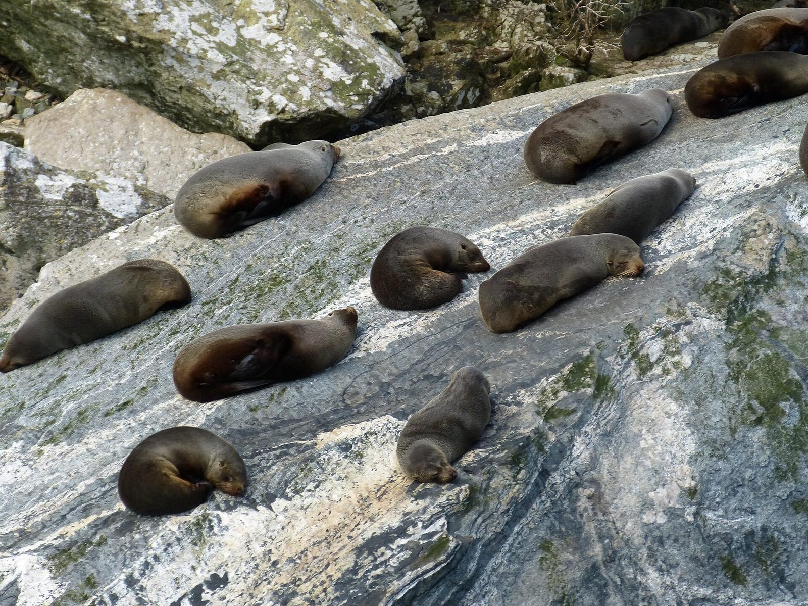
Wildlife: The sound is home to a resident pod of bottlenose dolphins, New Zealand fur seals that bask on rocks near the entrance, Fiordland crested penguins (July-November), and occasionally southern right whales and orcas. Underwater, the unique environment supports black coral growing at unusually shallow depths due to the tannin-stained freshwater layer.
Visiting Milford Sound
Distance from Te Anau: 119 kilometers via the Milford Road (State Highway 94), one of the world's most scenic drives. In good conditions the direct drive is about 1 hour 45 minutes, but most visitors should allow 2.5-3 hours with scenic stops.
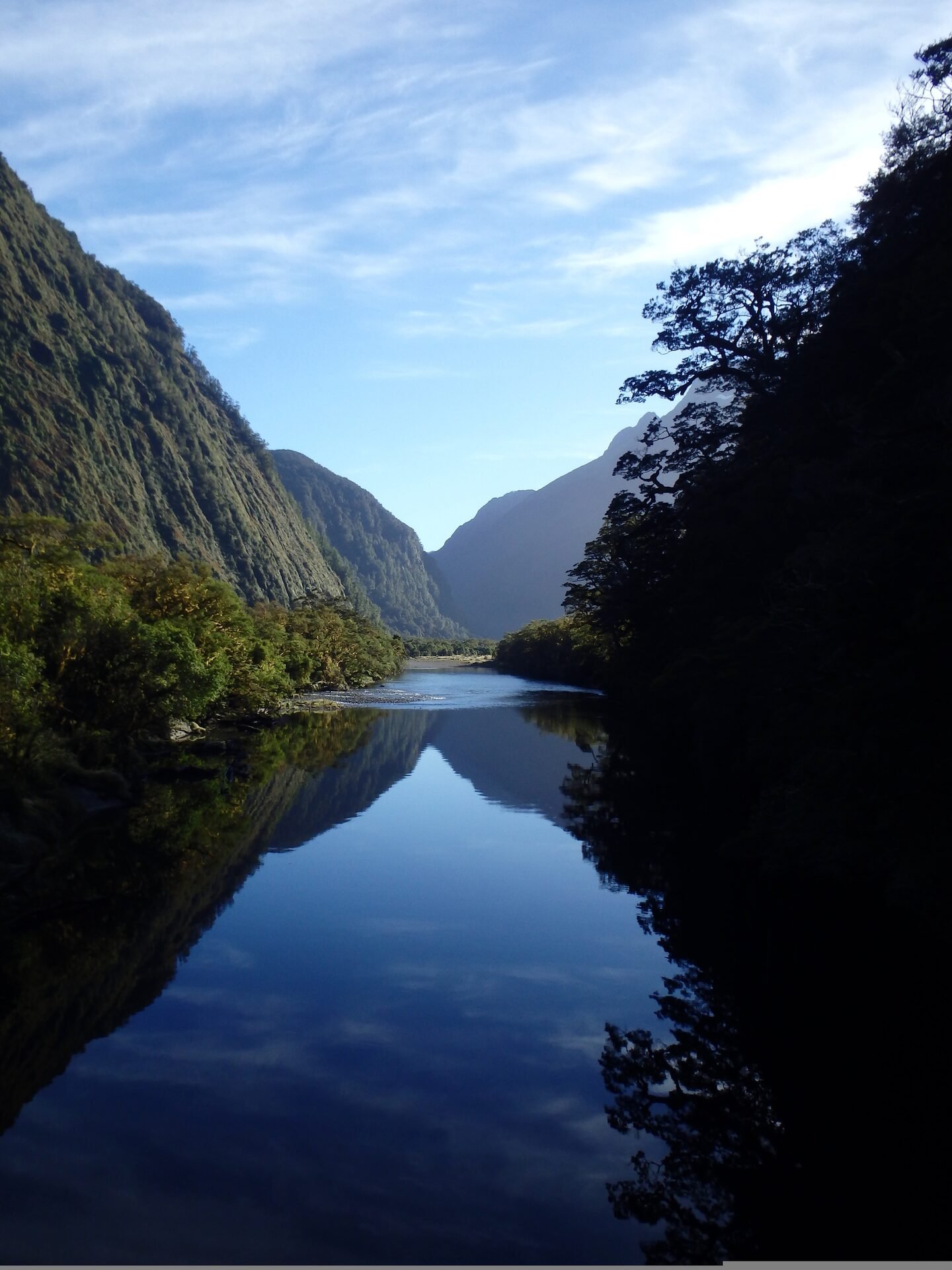
The Milford Road Journey: The drive itself is an attraction, featuring stops at Mirror Lakes (perfect mountain reflections), Knobs Flat (picnic area), Lake Gunn (easy nature walk), The Divide (lowest east-west pass in the Southern Alps), Pop's View (panoramic lookout), Homer Tunnel (1.2km hand-carved tunnel completed in 1954), The Chasm (water-carved rock formations), and numerous viewpoints.
Cruise Options: Multiple operators offer cruises ranging from 1.5-hour scenic cruises ($85-110 NZD) to 2-hour nature cruises with specialist guides ($110-140 NZD). Overnight cruises on the Milford Mariner or Milford Wanderer ($450-650 NZD) provide a unique experience with kayaking, wildlife viewing, and accommodation aboard the vessel.
Best Time to Visit: Milford Sound is spectacular year-round. Sunny days showcase the dramatic peaks, while rainy days (more common) create hundreds of temporary waterfalls. Early morning and late afternoon offer the best light for photography and fewer crowds.
Important Notes: The road can close due to avalanche risk (winter), flooding, snow, crashes, or road works. Check the Milford Road Planner for live conditions before travelling. There is a self-service petrol station at Milford Sound but it frequently runs out — always fill up in Te Anau. The Caltex is the only manned station in town, the rest are self-service. Limited cell phone coverage. Sandflies are prevalent - bring insect repellent.
Compare cruises, day trips, and scenic flight combos from Te Anau.
Common Mistakes to Avoid
- Pack lunch or snacks — there's a cafe at Milford Sound but options are limited
- Don't forget sandfly repellent - they're vicious at Milford
- Don't rely on cell phones - no coverage for emergencies
- Don't speed on Milford Road - it's dangerous and heavily policed
- Don't book cheapest cruise - quality varies significantly
Doubtful Sound - The Sound of Silence
Doubtful Sound (Patea in Māori) is New Zealand's deepest fiord and offers a more remote, pristine wilderness experience than Milford Sound. Three times longer and ten times larger than Milford, Doubtful Sound receives fewer visitors, providing an intimate encounter with untouched nature.
Unique Characteristics
Size and Depth: Doubtful Sound extends 40 kilometers inland with three distinct arms. The fiord reaches depths of 421 meters, making it New Zealand's deepest fiord. The surrounding mountains rise to over 1,000 meters, creating dramatic scenery.
Rainfall and Waterfalls: The area receives approximately 7 meters of rainfall annually, creating a unique environment where a permanent freshwater layer sits atop the saltwater. This creates hundreds of temporary waterfalls after rain and supports unique marine life including black coral at shallow depths.
Wildlife: Doubtful Sound is home to a resident pod of approximately 60 bottlenose dolphins, New Zealand fur seals, Fiordland crested penguins, and occasionally southern right whales. The remote location means wildlife is often more relaxed around boats.
Accessing Doubtful Sound
The Journey: Reaching Doubtful Sound is an adventure in itself, requiring three different modes of transport. First, a coach from Te Anau to Manapouri (20 minutes). Then a boat cruise across Lake Manapouri (45 minutes) to West Arm. Next, a coach journey over Wilmot Pass (671m elevation, 22km) through pristine rainforest. Finally, boarding your cruise vessel at Deep Cove in Doubtful Sound.
Day Cruises: Full-day tours (8-9 hours total, $299-349 NZD) include all transport, a 3-hour cruise of Doubtful Sound, and often a visit to the Manapouri Power Station (optional). Tours depart Te Anau morning and return late afternoon.
Overnight Cruises: For the ultimate Doubtful Sound experience, overnight cruises ($499-699 NZD) include all meals, comfortable cabin accommodation, kayaking opportunities, and the chance to experience the sound at dawn and dusk when wildlife is most active. The silence of Doubtful Sound at night, broken only by waterfalls and wildlife, is unforgettable. Browse and book experiences here.
Manapouri Power Station: New Zealand's largest hydroelectric power station is built 200 meters underground. Tours of this engineering marvel are available as part of some Doubtful Sound trips.
Day cruises and overnight experiences through this remote wilderness fiord.
Te Anau Glowworm Caves
The Te Anau Glowworm Caves are a magical underground world accessible only by boat from Te Anau. These caves, carved by an underground river, are home to thousands of glowworms that create a stunning bioluminescent display.
Cave Features
Geological Formation: The caves are relatively young in geological terms, only about 12,000 years old. They were formed by the underground Tunnel Burn stream carving through limestone. The caves continue to evolve, with the underground river still actively shaping the caverns.
Glowworms: The caves are inhabited by thousands of Arachnocampa luminosa, a species of fungus gnat found only in New Zealand. The "glowworms" are actually the larvae stage of these insects. They produce bioluminescent light to attract prey into their sticky silk threads. The darker and quieter the environment, the brighter they glow.
Underground Waterfalls: The caves feature several underground waterfalls where the Tunnel Burn cascades through the caverns. The sound of rushing water echoes through the limestone chambers, adding to the atmospheric experience.
The Cave Experience
Tour Details: The 2.5-hour tour ($95 adults, $35 children 5-15, under 5 free) begins with a scenic 25-minute cruise across Lake Te Anau aboard a modern catamaran. Upon reaching the western shore, expert guides lead small groups into the cave system.
Inside the Caves: The tour includes walking through limestone passages while guides explain the geology and ecology. You'll see the underground stream and waterfalls before boarding a small boat for a silent drift through the glowworm grotto. In complete darkness and silence, thousands of glowworms create a stunning display resembling a starry night sky.
Practical Information: Tours operate year-round with multiple daily departures. The caves maintain a constant temperature of 8-12°C, so bring warm clothing. Photography is not permitted in the glowworm grotto to protect the sensitive ecosystem and preserve the experience for all visitors. The tour involves some walking and low ceilings in places - not suitable for those with mobility issues.
Booking: Tours are operated exclusively by Real Journeys. Book in advance during peak season (December-February) as tours often sell out. Departures from Te Anau lakefront.
Cruise across Lake Te Anau and explore the magical underground glowworm grotto.
Pro Tips for Glowworm Caves
- Best Time: Last tour of the day (fewer people, darker = brighter glowworms)
- What to Wear: Warm jacket (caves are 8-12°C year-round)
- Photography: Not allowed in grotto, but you'll remember it forever
- Booking Tip: Book 2-3 days ahead in summer, day-of in winter
- Combo Deal: Some operators offer Milford + Caves packages (save 15%)
Te Anau is the calm centre between underground rivers, lake light, and exposed ridgelines.
Plan attractions as a sequence rather than a checklist: a cave or lake day, a fiord day, then a track or lookout when the weather opens.
Kepler Track - Great Walk
The Kepler Track is one of New Zealand's Great Walks, offering a 60-kilometer loop through some of Fiordland's most diverse and spectacular landscapes. Purpose-built in the 1980s to relieve pressure on the Milford and Routeburn Tracks, the Kepler has become a classic in its own right. For the full comparison of Kepler, Milford, Routeburn, and live DOC alerts, use the Great Walks guide.
As an attraction, the Kepler matters because it begins so close to Te Anau. Even if you are not doing the full 3-4 day loop, short sections like Brod Bay, Rainbow Reach, and the Control Gates give visitors a taste of Great Walk country without needing hut bookings.
Compare Kepler details, day-walk options, DOC alerts, and official booking links.
Lake Te Anau
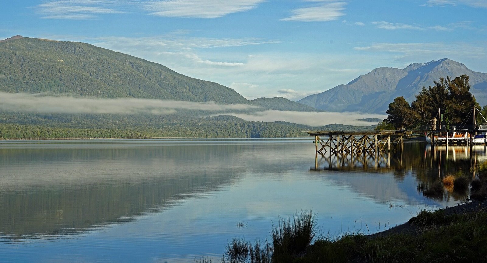
Lake Te Anau is New Zealand's second-largest lake, covering 344 square kilometers with a maximum depth of 417 meters. The lake's name comes from the Māori "Te Ana-au" meaning "the cave of swirling water," referring to the glowworm caves on its western shore.
Lake Features
Geography: The lake has three distinct arms (North, Middle, and South Fiords) extending into the mountains. These fiord-like arms were carved by glaciers during the ice ages. The lake is fed by numerous rivers and streams flowing from the surrounding mountains, keeping the water crystal clear.
Surrounding Mountains: The Murchison Mountains rise dramatically from the western shore, reaching heights over 2,000 meters. These mountains are home to the endangered takahē bird and are largely inaccessible except by helicopter or boat.
Islands: Several small islands dot the lake, including Pomona Island (the largest) and several smaller unnamed islands. These islands provide important habitat for native birds.
Activities on Lake Te Anau
Kayaking: The lake's sheltered bays and beaches make it ideal for kayaking. Paddle to secluded beaches, explore the shoreline, or venture into the fiords. Guided tours and rentals available from Te Anau lakefront. Best conditions typically in morning before afternoon winds.
Fishing: Lake Te Anau is famous for brown and rainbow trout. The lake and its tributaries offer excellent fishing opportunities. Popular fishing spots include the Eglinton River mouth, Whitestone River, and various bays around the lake. Fishing license required.
Boat Cruises: Scenic cruises explore the lake's three arms, offering views of mountains, waterfalls, and wildlife. Options range from 1-hour scenic tours to half-day explorations. The glowworm cave cruise is the most popular.
Swimming: Several beaches around Te Anau offer swimming opportunities in summer (December-February). Water temperature reaches 15-18°C. Popular swimming spots include Shallow Bay, beaches near the Kepler Track start, and various bays accessible by boat or kayak.
Lakefront Walks: The Te Anau lakefront features a scenic walkway perfect for strolling, jogging, or cycling. The path offers beautiful lake and mountain views with numerous benches and picnic spots. Particularly beautiful at sunrise and sunset.
Fiordland National Park
Fiordland National Park is New Zealand's largest national park, covering 1.2 million hectares of pristine wilderness. Established in 1952 and designated a UNESCO World Heritage site in 1990 as part of Te Wāhipounamu, Fiordland represents one of the world's great wilderness areas.
Park Features
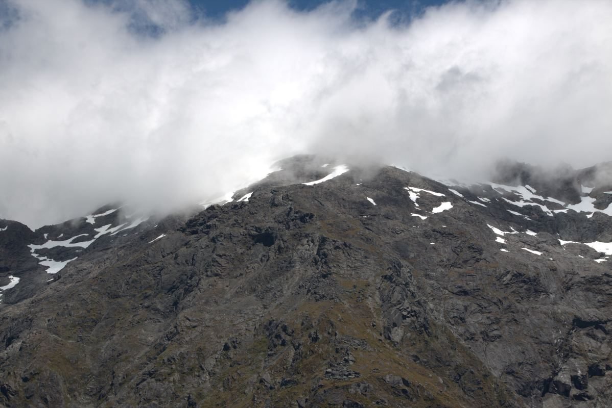
Landscape: The park encompasses dramatic fiords, ancient rainforests, alpine peaks, pristine lakes, and powerful waterfalls. Glaciers carved the landscape during ice ages, creating the distinctive U-shaped valleys and fiords. Mountains rise directly from sea level to over 2,700 meters.
Climate: Fiordland is one of the wettest places on Earth, receiving 6-8 meters of rainfall annually in some areas. This extreme rainfall creates hundreds of waterfalls and supports lush temperate rainforest. The weather can change rapidly - be prepared for all conditions.
Flora: The park protects extensive areas of ancient beech forest, podocarp forest, and alpine vegetation. Some trees are over 800 years old. The forest floor is carpeted with ferns, mosses, and lichens. Above the tree line (around 1,000m), alpine plants including mountain daisies and buttercups thrive.
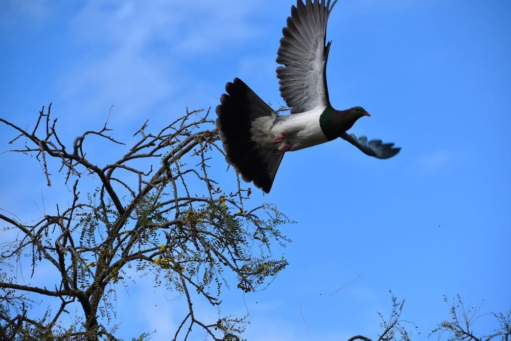
Fauna: Fiordland is home to many rare and endangered species. The takahē, once thought extinct, survives in the Murchison Mountains. Other notable species include kea (alpine parrot), kākāpō (critically endangered nocturnal parrot), mohua (yellowhead), blue duck (whio), and Fiordland crested penguin. The park is also home to New Zealand fur seals, bottlenose dolphins, and occasionally southern right whales.
Exploring Fiordland National Park
Great Walks: The main Te Anau-facing Great Walks are the Kepler Track, Milford Track, and Routeburn Track. Hump Ridge is also part of the official Great Walk family in Southern Fiordland, but is usually planned from Tuatapere. See the Great Walks & DOC Alerts page for the practical comparison.
Day Walks: Numerous shorter walks provide access to Fiordland's beauty. Popular options include Key Summit (3 hours return, alpine views), Lake Marian (3 hours return, alpine lake), Gertrude Saddle (6 hours return, challenging alpine route), and various walks along the Milford Road.
Fiords: Milford Sound and Doubtful Sound are the most accessible fiords, but the park contains 14 fiords in total. Others include Dusky Sound, Breaksea Sound, and George Sound - accessible only by boat or aircraft.
Conservation: The park faces ongoing conservation challenges including invasive species (stoats, rats, possums) that threaten native birds. DOC operates extensive predator control programs. Visitors can help by checking for seeds and insects before entering the park, staying on marked tracks, and reporting any pest sightings.
Visitor Information
DOC Visitor Centre: Located on Lakefront Drive in Te Anau, the centre provides essential information about the park, current track conditions, weather forecasts, and conservation programs. Free entry with excellent displays about Fiordland's ecology and history. Open daily 8:30am-4:30pm (extended hours in summer).
Safety: Fiordland's weather is unpredictable and can be severe. Always check forecasts, carry appropriate clothing and equipment, and inform someone of your plans. Cell phone coverage is limited or non-existent in most of the park. Carry a personal locator beacon (PLB) for multi-day trips.
Permits and Bookings: Great Walk huts and campsites require advance booking during peak season. Day walks generally don't require permits, but check with DOC for current requirements. Hunting and fishing require appropriate licenses.
Other Notable Attractions
Te Anau Bird Park
Free bird park adjacent to the DOC Visitor Centre featuring takahē, native ducks, and other birds. The park plays an important role in takahē conservation. Open 24/7 with best viewing morning and evening. Easy walking paths suitable for all ages and abilities.
Mirror Lakes
Located 58km from Te Anau along the Milford Road, Mirror Lakes offer perfect reflections of the Earl Mountains on calm days. A short 5-minute walk from the car park leads to viewing platforms. Best visited early morning before winds disturb the water. The name signs are installed upside down so they read correctly in the reflection.
The Chasm
A short 20-minute return walk from the Milford Road (90km from Te Anau) leads to The Chasm, where the Cleddau River has carved fascinating rock sculptures through solid rock. The water has created potholes, bowls, and smooth curves in the granite. Particularly impressive after rain when water flow is high.
Lake Manapouri
Often called New Zealand's most beautiful lake, Lake Manapouri is located 20km south of Te Anau. The lake features numerous islands and is surrounded by mountains. It's the starting point for Doubtful Sound tours and home to New Zealand's largest hydroelectric power station. Scenic cruises and kayaking available.
Mavora Lakes
Two pristine alpine lakes (North and South Mavora) located 60km north of Te Anau via gravel road. These remote lakes offer excellent fishing, camping, and hiking. The area was used as a filming location for "The Lord of the Rings" trilogy. Basic DOC campsite available.
Attractions FAQ
Yes, a Milford Sound day trip from Te Anau takes 10-13 hours total. The drive is 119km each way (2.5 hours). Most visitors leave Te Anau by 7-8am, cruise Milford Sound, and return by 5-7pm. You can self-drive or take a guided tour bus.
Absolutely. The Te Anau Glowworm Caves are a unique experience you can't replicate elsewhere. The 2.5-hour tour ($95 adults) includes a boat ride across Lake Te Anau and a guided cave walk culminating in a silent drift through the glowworm grotto. Most visitors rate it as a highlight of their trip.
Milford Sound is more dramatic and accessible (2.5 hour drive). Doubtful Sound is more remote, peaceful, and three times larger — but requires a full day to visit. If you have time for only one, choose Milford Sound. If you want a more intimate wilderness experience with fewer tourists, choose Doubtful Sound. Ideally, visit both.
The full 60km Kepler Track requires moderate fitness — you'll walk 14-16km per day with significant elevation changes (1,400m total gain). Day 2's alpine section is the most demanding. However, you can do shorter day walks: Brod Bay return (9km, easy, 2 hours) or Luxmore Hut return (27.6km, challenging, 8-10 hours) without committing to the full track.
Yes, Lake Te Anau is safe for swimming in summer (December-February) when water temperatures reach 15-18°C. Popular swimming spots include Shallow Bay and beaches near the Kepler Track start. The water is clean and clear. Always supervise children and be aware that the lake can get cold quickly — even in summer it's brisk!